Land ownership and property verification play a crucial role in real estate transactions, legal clarity, and investment safety. In Gujarat, the government has significantly simplified this process through the Bhu Naksha Gujarat portal, a digital platform that allows citizens to access land maps, survey numbers, and plot boundaries online.
With increasing demand for transparent and verified property information, Bhu Naksha Gujarat 2025 serves as an essential tool for landowners, buyers, investors, and legal professionals. This article provides a detailed and descriptive guide on how to access Gujarat land maps online, understand the portal’s benefits, and use supporting platforms like AnyROR Gujarat effectively.
Table of Contents
What is Bhu Naksha Gujarat?
Bhu Naksha Gujarat is an official online cadastral mapping system developed by the Gujarat Revenue Department. The portal hosts digitized village-wise land maps that clearly display plot boundaries and survey numbers.
These cadastral maps are prepared based on official land records and help users visually identify land parcels without physically visiting revenue offices.
Key Information Available on Bhu Naksha Gujarat
Through the portal, users can access:
- Survey number and sub-division details
- Village-level land maps
- Accurate plot boundaries and measurements
- Land classification such as agricultural or non-agricultural
- Reference ownership details (linked with AnyROR records)
This system strengthens transparency and reduces dependency on manual land record verification.
Importance of Bhu Naksha Gujarat for Landowners and Buyers
Before purchasing land or applying for registration, it is essential to verify land boundaries and survey details. Bhu Naksha Gujarat helps users visually confirm the exact location and size of a land parcel, minimizing the risk of disputes.For government bodies, planners, and developers, the portal supports land-use planning and infrastructure development by providing reliable and updated mapping data.
Benefits of Using Bhu Naksha Gujarat Online
The Gujarat Bhu Naksha portal offers several advantages that make land record access easier and more efficient:
- Convenience: Access land maps anytime from anywhere
- Transparency: Clear visualization of land boundaries and survey numbers
- Accuracy: Digitized and government-verified cadastral maps
- Time-saving: No need to visit revenue offices
- Cost-effective: Completely free to use
- Dispute prevention: Helps identify encroachments and boundary overlaps
These benefits make Bhu Naksha Gujarat an essential resource for property verification.
Details Required to Check Bhu Naksha Gujarat Online
To access land maps online, users do not need to upload any documents.
Basic information required:
- District
- Taluka
- Village name
- Survey number
Using these details, anyone can check Gujarat land maps online through official portals.
Step-by-Step Guide to Access Bhu Naksha Gujarat Land Map Online

Step 1: Visit the Official Portal
Go to the Gujarat Revenue Department website: https://revenuedepartment.gujarat.gov.in
This is the authorized source for accessing village maps and land-related services.
Step 2: Open the Village Maps Section
On the homepage, locate and click on the “Village Maps” or “Bhu Naksha” option.
This section provides district-wise access to Gujarat land maps.
Step 3: Select District and Taluka
Choose the district where the land is located, followed by the taluka.
The portal will then display a list of villages under the selected taluka.
Step 4: Choose the Village
Select the specific village name to open its cadastral map.
Step 5: Locate the Survey Number
Within the village map interface, enter or identify your survey number.
The map will highlight the corresponding land parcel with clear boundaries.
Step 6: View Land Map Details
You can zoom in and move around the map to examine plot dimensions and neighboring survey numbers for better clarity.
How to Download Gujarat Bhu Naksha Land Map
Once the land map is displayed on the screen, downloading it is straightforward:
- Click on the Download or Print option
- Save the land map in PDF or image format
- Print the file if a physical copy is required
The downloaded Bhu Naksha map can be used for reference, legal verification, or property transactions.
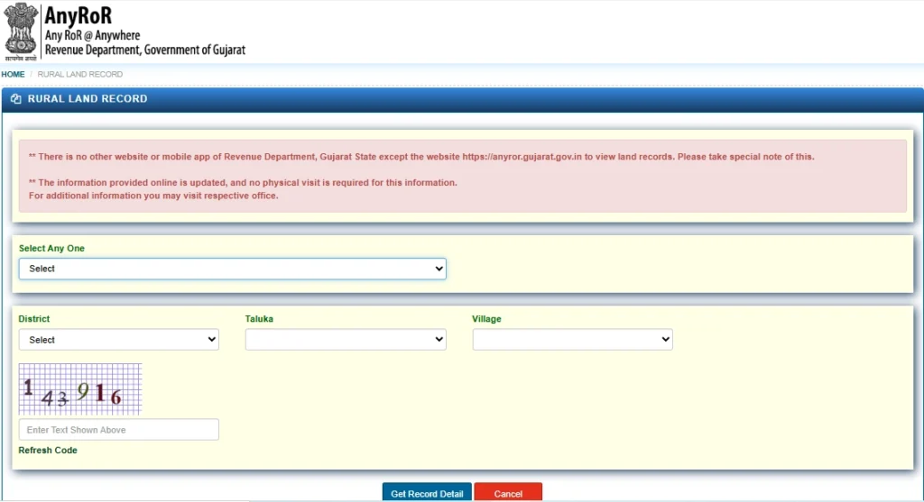
AnyROR Gujarat Portal: Access Ownership and RoR Records
While Bhu Naksha Gujarat provides land maps, AnyROR Gujarat offers detailed Record of Rights (RoR) information.
Records Available on AnyROR Gujarat
- 7/12 Utara (land ownership and cultivation details)
- 8A Khata information
- Property search by survey number or owner name
- Rural and urban land record access
To use the portal:
- Visit https://anyror.gujarat.gov.in
- Select Rural or Urban land records
- Enter district, taluka, village, and survey number
- View and download the required documents
Using Bhu Naksha together with AnyROR ensures complete land verification.
Alternative Ways to Access Bhu Naksha Gujarat
If online access is unavailable, land maps can also be obtained through offline channels:
- e-Dhara Centers for digitized land services
- District Revenue Offices
- Authorized land record service centers
Carrying accurate survey and village details will help speed up the process.
Mobile Accessibility and Language Support
The Gujarat Revenue Department has made land services more accessible through:
- UMANG mobile application
- Mobile-friendly website interface
- Language support in Gujarati, English, and Hindi
This ensures easy access for users across urban and rural areas.
Data Security and Authenticity of Land Records
The land record system in Gujarat is secured through advanced digital infrastructure:
- e-Dhara Land Records Management System replaces manual records
- Documents are authenticated using NIC e-Seal digital signatures
- Government-controlled data ensures reliability and legal credibility
These measures help prevent fraud and unauthorized alterations.
Gujarat Revenue Department Contact Details
For assistance related to land maps or records:
- Toll-Free Helpline: 1800 233 5500
- Head Office: Block No. 11, New Sachivalaya, Gandhinagar, Gujarat
- Appeals Email: dc-revappeals@gujarat.gov.in
Frequently Asked Questions
Is Bhu Naksha Gujarat free to access?
Yes, the portal provides free public access to land maps.
Can I check Gujarat land maps using a survey number?
Yes, land maps can be checked using district, village, and survey number.
Is Bhu Naksha Gujarat legally valid?
The maps are official government records used for reference and verification.
Can land maps be accessed on mobile phones?
Yes, through mobile browsers and the UMANG app.
Conclusion
The Bhu Naksha Gujarat 2025 portal is a major step towards transparent, efficient, and accessible land record management. By enabling online access to village maps and survey details, it empowers landowners and buyers to make informed decisions. When used alongside AnyROR Gujarat, it offers a complete solution for land verification, reducing disputes and improving confidence in property transactions.
More Information
Stay updated with the latest real estate insights, land record guides, and property verification tips by following Openplot.
Openplot helps buyers and sellers access verified property information, making every real estate decision safer and more informed.
Frequently Asked Questions
Q. Is Bhu Naksha Gujarat available for all districts?
A. Yes, the Gujarat government has digitized land records for all districts, but some areas may still be under process.
Q. Can I download a certified copy of the land map from Bhu Naksha Gujarat?
A. The online version is for reference. For a certified copy, visit the local revenue office or e-Dhara center.
Q. What should I do if my land details are incorrect on Gujarat Bhu Naksha?
A. If you notice errors, you should contact the Revenue Department or file a correction request at the local e-Dhara center.
Q. Is there a mobile app for Gujarat Bhu Naksha?
A. As of now, the government has not launched an official mobile app, but you can access the website through your mobile browser.